Category:Wharepapa / Arthur Range
Jump to navigation
Jump to search
| Object location | | View all coordinates using: OpenStreetMap |
|---|
mountain range in New Zealand  | |||||
| Upload media | |||||
| Instance of | |||||
|---|---|---|---|---|---|
| Located in protected area | |||||
| Location |
| ||||
| Has part(s) | |||||
| Elevation above sea level |
| ||||
 | |||||
Subcategories
This category has the following 2 subcategories, out of 2 total.
A
- Mount Arthur (New Zealand) (69 F)
T
Media in category "Wharepapa / Arthur Range"
The following 4 files are in this category, out of 4 total.
-
 Arthur Range 01.jpg 3,094 × 1,071; 1.82 MB
-
 Arthur Range 02.jpg 3,222 × 838; 1.46 MB
-
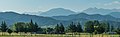 Arthur Range 03.jpg 3,391 × 1,050; 2.01 MB
-
 Arthur Range 04.jpg 3,223 × 1,836; 3.28 MB
